News/Events
Back
News
Events
Resources
Back
videos
Case Studies
Articles
CONTACT US
Home
Presentations
Back
Webinars
TMTW presentations
Video Cases
Training
Back
Product training
Software training
Product Overviews
Back
Top 5 reasons
Demos
Brands
Back
AG Geophysical
Benthos
BlueView
Bowtech
Cable Solutions
Cormon
DGO
Gavia
Impulse
Impulse PDM
Oceanscience
ODI
Odom Hydrographic
PDS
RD Instruments
RESON
SeaBotix
TSS
Webb Research
MARINE Channel
Home
Training
Product training
Software training
PDS training
Demos
Brands
AG Geophysical
Benthos
BlueView
Bowtech
Cable Solutions
Cormon
DGO
Gavia
Impulse
Impulse PDM
Oceanscience
ODI
Odom Hydrographic
PDS
RD Instruments
RESON
SeaBotix
TSS
Webb Research
Video Contest 2026
<p>Your web browser does not support iframes, which means that the video cannot play.</p>
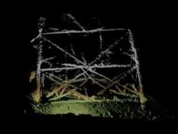
ProMapper Bridge
ProMapper is a geo-mosaicing software package that utilizes the BlueView 2D imaging sonar solution to create maps of areas imaged.
ProMapper Bridge
4.375
934
Share
Embed
Email
Download
Link to share
Embed this video
Send to a friend
Send
Download this video
Standard
(1MB)
HD
(1MB)
Download this video
Standard video
(1 MB)
HD video
(1 MB)
Full HD version
(1 MB)
00:51
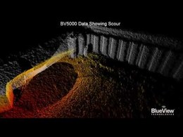
BlueView BV5000 Underwater Inspection of an Oil Platform
5,039 views
00:26
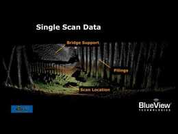
Underwater Bridge Inspection
4,905 views
00:40
3D Multibeam Scanning Sonar Lock Undercut
3,716 views
02:09
Using the M900-2250-130 2D Imaging Sonar to Inspect...
3,423 views
01:08
BlueView Spool Piece Metrology
2,634 views
00:47
BlueView Arc 3D Bridge Inspection
2,550 views