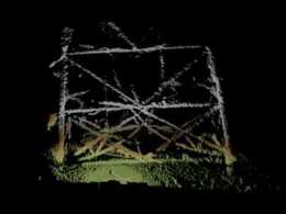
BlueView 3D Scan Drydock Gate
3D Inspections and Surveys
This 3D sonar imagery was taken during a hands-on demo held by BlueView and Seatronics in Aberdeen, Scotland. The high resolution imagery shows the advantages of the BV5000 when used as an inspection/survey aid. In this example, the BV5000 was lowered to the harbor bottom at four (4) different locations in front of a dry dock. A total of (4) 3D scans were captured in less than an hour of total collection time and then combined using Cyclone software to achieve a complete 3D point cloud of the dry-dock gate structure. One can clearly see the structure of the dry dock gate, the pilings, the slope of the bottom up to the gate and the sharp drop in elevation to the right of the gate. Additionally, you can see the depressions in the harbor floor just in front of the dry dock that are created when the gate folds down into the mud. In low or zero visibility conditions, BlueView's easy to obtain 3D imagery is ideal for inspecting and surveying underwater structures.